
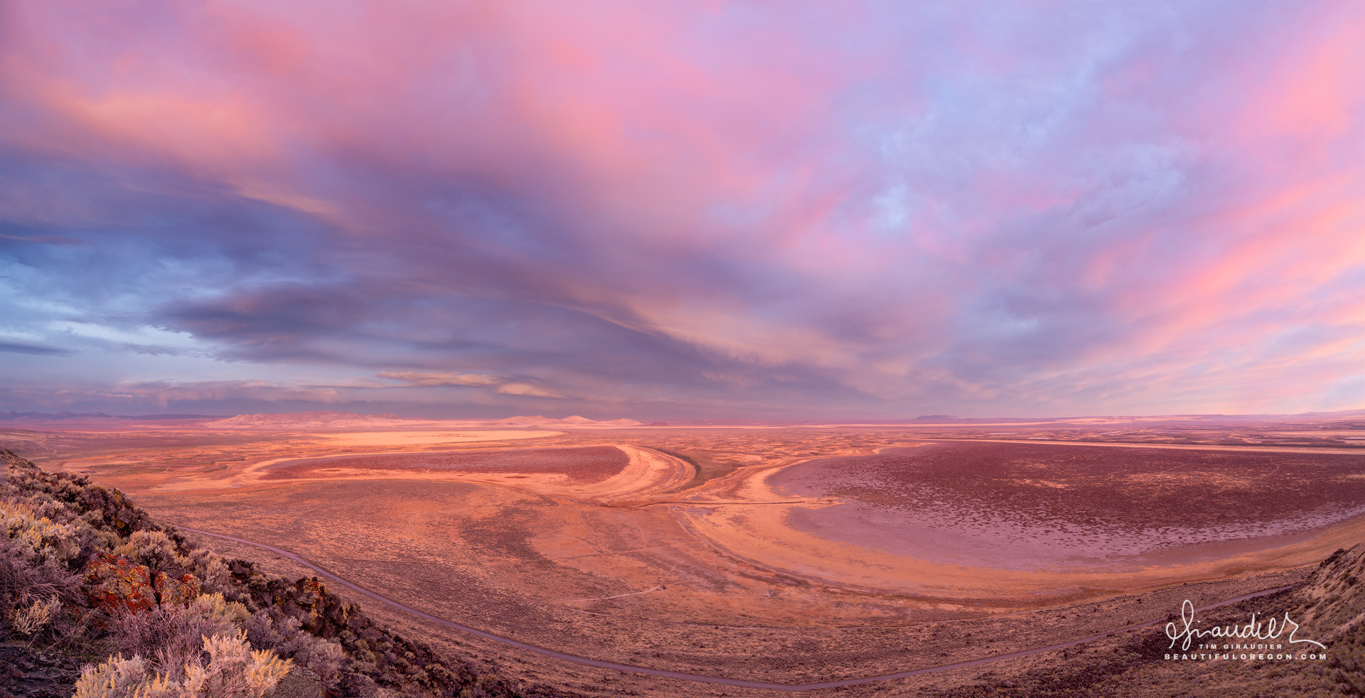
Warner Valley – Lake County Eastern Oregon
$ 57.60
& Livraison gratuite plus de 60€From the Hart Mountain overlook, the warm glow of pink light casts an otherworldly appearance over the sand dunes and empty lake basin Warner Valley. The human history of Warner Valley in southeast Oregon spans thousands of years and reflects the deep connections between indigenous peoples, early Euro-American exploration, settlement, and eventual economic development. This history is marked by significant shifts in land use, subsistence practices, and the arrival of modern infrastructure throughout the region. The description below outlines some of the key historical periods and human activities within Warner Valley. Based on archaeological evidence, human presence within Warner Valley extends back over 10,000 years. The region was home to indigenous people, and in particular the Northern Paiute tribes, whose ancestors lived in the area for millennia. Early human occupation of Warner Valley corresponds to a time when the climate was cooler and wetter, supporting a rich variety of plant and animal life, particularly around the valley’s vast lakes and wetlands. The indigenous people of Warner Valley were hunter-gatherers, who relied on a wide range of natural resources. The valley’s wetlands and lakes, particularly the Warner Lakes, were crucial to their subsistence. These environments provided fish, waterfowl, and aquatic plants such as wokas (yellow pond lily seeds), which were a major food source. Archaeological evidence, including projectile points, stone tools, and processing sites, points to sophisticated lithic (stone) technology used for hunting large game like deer and antelope, as well as smaller mammals and birds. The Northern Paiute were also adept at using natural materials to make baskets, boats, decoys, clothing and a wide variety of tools for gathering and storing food. The region’s natural features, such as lakes, springs, and rock formations, held cultural and spiritual significance for the Northern Paiute. The petroglyphs found on rock faces throughout Warner Valley are a testament to the long-standing human presence and cultural practices in the area. The arrival of Euro-Americans in Warner Valley began in the early to mid-19th century, as explorers, fur trappers, and military expeditions passed through the region. One of the first recorded non-indigenous explorations of the area was by John C. Frémont in the early 1840s during his expedition through the Great Basin. In the early 1800s, fur trappers from the Hudson’s Bay Company and other trading outfits likely passed through Warner Valley, although the region’s remote location limited extensive trapping operations compared to other parts of the Pacific Northwest. Frémont’s expeditions, along with those of other explorers, helped to map the region and opened it up for further exploration and potential settlement. These expeditions also documented the valley’s lakes and wetlands, which were seen as possible sources of water for future settlers. In the latter half of the 19th century, Euro-American settlement in the Warner Valley increased, primarily with the establishment of ranching and homesteading communities. This period saw significant changes in land use and also led to conflicts between settlers and indigenous inhabitants. The passage of the Homestead Act of 1862 encouraged settlement in remote areas like Warner Valley, and European settlers began claiming land for cattle ranching, a practice that became the primary economic activity in the region. The valley’s wetlands were drained or altered to create pastureland for livestock, profoundly affecting the landscape and indigenous lifeways. The expansion of settlers into Warner Valley led to conflicts with the Northern Paiute people, culminating in the Bannock War of 1878. This conflict was part of the broader Indian Wars that occurred throughout the West during the late 19th century. After the war, many Paiute people were displaced, and those who remained were confined to reservations, further disrupting their traditional ways of life. After the Bannock War and the establishment of ranching as the dominant economic activity, Warner Valley developed into a region largely defined by its ranching operations, which remain central to the area’s economy today. Warner Valley became known for large-scale cattle ranching operations, with ranchers grazing thousands of cattle on the valley floor and surrounding range lands. The availability of water from the Warner Lakes made the valley particularly attractive for ranchers despite its remote location. By the early 20th century, competition for water resources in Warner Valley intensified. Water rights were established for irrigation and livestock, and ditches and canals were constructed to manage the limited water supply. This period also saw some of the valley’s wetlands drained to expand grazing land. Throughout the 20th century, Warner Valley remained relatively remote, with limited infrastructure and development. However, roads and transportation networks slowly improved, connecting the valley to larger markets and making it easier to transport cattle and agricultural goods. The construction of roads like Highway 140, which passes through Warner Valley, helped facilitate transportation and trade. This improvement allowed ranchers and farmers to move cattle and goods more efficiently, further embedding ranching in the local economy. In recent decades, there has been growing recognition of the ecological importance of Warner Valley’s remaining wetlands and lakes. Portions of the valley, such as the Warner Wetlands Area of Critical Environmental Concern (ACEC), have been protected to preserve habitat for wildlife, including migratory birds and endangered species. Conservation efforts also focus on maintaining water quality and restoring damaged ecosystems. Today, Warner Valley also attracts outdoor enthusiasts, including birdwatchers, hikers, hunters, and naturalists, who come to experience the region’s stark beauty and rich biodiversity. The valley’s unique geologic and ecological features, including its playas and hot springs, draw visitors interested in the area’s natural history. The human history of Warner Valley is one of deep indigenous roots, marked by a reliance on the valley’s natural resources for thousands of years. The arrival of Euro-American settlers in the 19th century led to significant cultural and ecological changes, with ranching becoming the dominant land use. Today, Warner Valley is a place where traditional ranching coexists with efforts to preserve its unique ecological heritage, reflecting a complex history of human interaction with this remote and rugged landscape. GEOLOGIC HISTORY OF THE WARNER VALLEY The Warner Valley in southeastern Oregon has a rich geologic history shaped by volcanic activity, tectonic forces, and the gradual processes of erosion and sedimentation. This basin-and-range landscape, characteristic of much of the Great Basin region, is home to dramatic landforms, including fault-block mountains, playas, and geothermal features. A summary of geologic history and its evolution within the Warner Valley: Tectonic Formation (Miocene Epoch – 23 to 5 million years ago): The geologic foundation of Warner Valley was primarily shaped during the Miocene Epoch, when significant tectonic forces influenced the western United States. The region is part of the Basin and Range Province, where the Earth’s crust is being stretched and pulled apart by tectonic forces. As the crust extended, large blocks of land either rose or dropped along fault lines, creating the alternating mountain ranges and valleys characteristic of the region. Horst and Graben Formation: Warner Valley is part of a graben, a block of land that has dropped relative to surrounding blocks (known as horsts). The Warner Mountains, which rise to the east, are the result of these uplifting forces. This faulting continues today, making Warner Valley part of an active tectonic region. Volcanic Activity (Oligocene to Miocene Epoch – 30 to 5 million years ago): During the Oligocene and Miocene epochs, southeastern Oregon was a hot spot of volcanic activity. Large volcanic eruptions in the region contributed to the deposition of thick layers of basalt lava that covered much of the area. The basalt flows from this period can still be seen today in the valley and surrounding ranges. These eruptions were part of the widespread volcanic activity associated with the development of the Columbia River Basalt Group and other regional volcanic systems. The volcanic rocks in the area also include ash deposits from eruptions of nearby volcanic centers, such as those in the High Lava Plains and Steens Mountain. These ash layers and lava flows helped shape the valley’s present landscape, creating a mix of volcanic terrain. Lake Formation and Glaciation (Pleistocene Epoch – 2.6 million to 11,700 years ago): During the Pleistocene Epoch, a series of glacial cycles had a profound impact on the region. While the Warner Valley itself was not heavily glaciated, the cooler, wetter climate of the time caused the formation of large lakes in the valley. These ancient lakes filled much of the Warner Basin, creating a series of interconnected lake systems. Warner Lakes: The Warner Valley is now home to a series of shallow lakes and dry lake beds that are the remnants of a much larger Pleistocene lake system. During wetter periods, large lakes would have filled the valley, connecting areas like Hart Lake, Crump Lake, and Pelican Lake. Over time, as the climate became more arid during the Holocene (the last 11,700 years), these lakes receded, leaving behind the smaller water bodies and playas that exist today. Erosion and Sedimentation: As the tectonic forces continued to shape the landscape and the volcanic activity waned, erosion from wind and water became dominant. Streams carried sediments from the surrounding mountains into the Warner Valley, filling the basin with alluvial deposits. The flat valley floor is primarily composed of these eroded sediments, which accumulated over millennia. Wind erosion also contributed to the shaping of the valley’s features, particularly the formation of sand dune sand the development of the flat, arid playas. During periods of lake expansion, fine sediments were deposited in the shallow lakes, creating the thick layers of silt and clay that now cover the valley floor. Geothermal Activity: Warner Valley is located in a region with significant geothermal activity due to the continuing tectonic forces beneath the basin. There are numerous hot springs in the region, which are evidence of the geothermal energy below the surface. These springs, such as those near Hart Mountain, are remnants of the volcanic and tectonic processes that have shaped the region over millions of years. Modern Geology and Hydrology: Today, Warner Valley’s geologic features include: Fault-block mountains: The Warner Mountains to the east are a prominent feature formed by the faulting processes that created the basin-and-range topography. Playas: Dry lake beds like Warner Playa are remnants of the larger Pleistocene lake system. These playas fill with water during the wet season, but dry out during summer months, creating expansive salt flats. Hot springs and geothermal features: These are scattered throughout the region, especially near the base of fault lines. The geologic history of Warner Valley, Oregon, is a complex narrative of tectonic extension, volcanic activity, and sediment deposition. Shaped by the forces that define the Basin and Range Province, the valley’s landscape is marked by fault-block mountains, volcanic rocks, ancient lake beds, and geothermal activity, all of which make it a region of significant geologic interest and a testament to the dynamic processes that have shaped the western United States. Hart Mountain Antelope Reservation, Lake County. Landscape photography of Eastern Oregon and the Northern Great Basin and Range. Lake County, Southeast Oregon, Sunrise, Warner Valley
Produits similaires
-
CAMERA PTZ CANON CR-N700 NOIRE $ 99.61